


Les plans d'Hotonnes

cailloux54
User
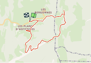

Length
10.3 km

Max alt
1268 m

Uphill gradient
333 m
Km-Effort
14.8 km

Min alt
1040 m

Downhill gradient
333 m
Boucle
Yes
Creation date :
2015-02-08 00:00:00.0
Updated on :
2015-02-08 00:00:00.0
3h50
Difficulty : Medium

FREE GPS app for hiking
 SityTrail
IGN / Geographical institutes
SityTrail Plus
The world is yours!
About
Trail Snowshoes of 10.3 km to be discovered at Auvergne-Rhône-Alpes, Ain, Haut Valromey. This trail is proposed by cailloux54.
Description
randonnée avec arrêt au restaurant Berthet, Fondue tarte au myrtilles et retour aux voitures de nuit
Positioning
Country:
France
Region :
Auvergne-Rhône-Alpes
Department/Province :
Ain
Municipality :
Haut Valromey
Location:
Hotonnes
Start:(Dec)
Start:(UTM)
709211 ; 5102050 (31T) N.
Comments